
A recent report from Texans for Natural Gas (TNG) brought the encouraging news that, in 2022, Texas producers drove methane intensity to a record low of 0.12 percent. This is a positive trend as governments are striving to lower methane emissions.
This report comes at a crucial time, as in November of 2023, the COP28 conference generated widespread enthusiasm around the detection and remediation of methane leaks as a way of meeting new emissions goals. During the COP28 conference, according to Reuters, the EPA unveiled a new set of rules for the oil and gas and energy industries – asking that these industries slash methane emissions by 30 percent by the end of the decade and keep roughly 58 million tons of methane out of the atmosphere over the next fourteen years – a number nearly equivalent to all 2021 carbon dioxide emissions from the power sector.
This TNG report provides a positive step in this direction. For instance, according to the same report, between 2011 and 2022, methane emissions intensity in the Permian Basin fell by nearly 85 percent, even though total oil and gas production increased in the same period by over 416 percent.
What’s responsible for this drop in emissions? Many factors are at play here, but what’s undeniable is that emergent technologies have played an important role. Over the past two decades, the U.S. oil and natural gas industry has invested more than $300 billion in technologies to mitigate greenhouse gas emissions, and we are now seeing those investments pay off in a significant way.
Of these emergent technologies, perhaps the most significant, has been geospatial analytics, which many industry players now view as essential to reducing emissions and keeping communities safe. Combined with artificial intelligence (AI) and remote sensing technology, geospatial analytics has ushered in a new, climate-friendly era for the oil and gas industry, helping demonstrate that high production levels and lower emissions are compatible goals. Understanding this technology – how it works and why it matters – can tell us a lot about what the fight against global warming will look like this decade.
What is Geospatial Analytics?
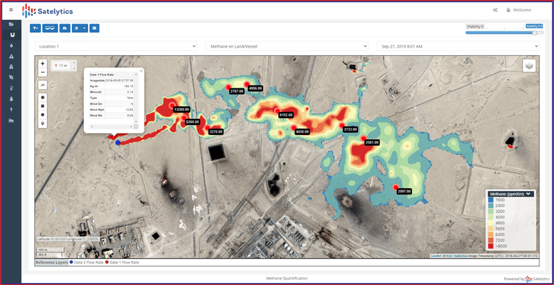
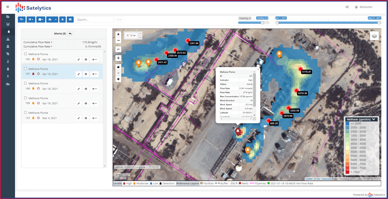
Put simply, geospatial analytics leverages a wide range of information – including geographical information, spatial data, location data, and, increasingly, high-resolution imagery and computer vision – to extract the kind of clear, structured insights that can help oil and gas producers identify and remediate potential problems. It can take in the full scope of an oil or gas company’s infrastructure and operations and automatically pinpoint issues like methane leaks, liquid pipeline leaks, and right-of-way encroachments.
All of this has been enabled by the ongoing revolution in big data, cloud computing, and artificial intelligence, which collectively have enabled the analysis of massive quantities of data at a speed and scale previously unimaginable.
By detecting these problems early, AI-enhanced geospatial analytics can help oil and gas producers stop these problems almost as soon as they’re identified, in turn saving companies time and money and ensuring the most strategic allocation of resources. Instead of a chaotic array of disparate, hard-to-read, and often incompatible data streams, oil and gas producers can now quickly act on streamlined, clarified information.
The key benefit of this technology in an oil and gas context is the ability to identify incidents early and stop them before they sprawl out of control. Companies are granted rapid insight into risks the moment they emerge and are then able to take actions that minimize costly consequences to communities, the environment and the company itself. Critical to its success, AI is self-correcting, which means if a threat is misidentified, the AI can learn from its mistake.
In the specific case of the Permian Basin – where Satelytics, a geospatial analytics company, is helping to organize a collaborative effort to help ease access to this technology – over 40 complex algorithms are at play. Collectively, these ingest and synthesize countless terabytes of data daily. The speed with which these algorithms deliver insights, flagging concerning events in a matter of hours, partially explains how methane emissions have decreased so dramatically in such a short period. It is a testament to a fact known by anyone who works in the oil and gas industry; namely, that when it comes to cutting emissions, geospatial analytics is among the best weapons.
Looking Ahead: Not All Geospatial Analytics are Created Equal
In the weeks following the COP28 conference, multiple non-governmental organizations (NGOs) launched their own “greenhouse gas trackers” to help pinpoint leaks. Unfortunately, most of these trackers are using coarse-resolution satellite data that delivers little more than generalities, as opposed to the concrete, specific information oil and gas companies need to make important decisions.
What is clear from the Permian Basin’s experience is that if the U.S. oil and gas industry is actually to meet the EPA’s ambitious goals, or our international climate commitments, this kind of generalized satellite data can prove inadequate. If the goal is to save the planet from global warming, we cannot act retroactively: Leaks need to be identified as they happen if damaging consequences are to be prevented. AI-enhanced geospatial analytics can provide the kind of fine-grained, near real-time information oil and gas companies need to continue reducing emissions.
To underline the disparity between these “greenhouse gas trackers” and AI-enhanced geospatial analytics, it’s worth comparing their technical specifications. The former makes use of satellite imagery with lower resolution somewhere in the range of 25 to 7500 meters. AI-enhanced geospatial analytics, by contrast, uses the highest available resolution: 3.7 meters. This aspect means that, using geospatial analysis, oil and gas companies can identify even minuscule disruptions at the component level; for instance, a leaky valve at a well site. This kind of detail is virtually impossible with the kinds of satellite imagery still deployed by many oil and gas businesses.
Ultimately, three key factors will determine the success of oil and gas companies in meeting emissions goals. These are:
1) Accurate data: Oil and gas companies require the kinds of granular insights that only superior data permits, including specific information on emission type as well as the location of the emission source, in addition to accurate calculation of total plume and flow rate.
2) Latency, or time-to-results: Oil and gas companies must be able to procure information quickly – in hours versus days or weeks – so they can correct problems at the source before they spiral out of control.
3) Multipurpose analysis: Methane leaks are important, but there are other dangers, and the most advanced technology needs to be applied to these issues, as well. That includes methane measurement, liquid leak detection, encroachment, land movement, land-use classification, change detection, water erosion, theft detection and more. The more costly high-resolution data needs to be analyzed in multiple ways to extract maximum value from it.
As the TNG report makes clear, AI-powered geospatial analytics is among the best options we have for helping to reduce emissions and combat global warming. To do this effectively, this technology needs to incorporate the widest possible range of multispectral and hyperspectral data, including data from commercial satellites, aircraft and fixed cameras, while leveraging machine learning algorithms to isolate spectral signatures.
The COP28 plans may seem ambitious but, with the right technology, they can be achievable.
Headline photo: Pipeline operators can monitor remote facilities and infrastructure for methane leaks with
AI-powered geospatial analytics.

Sean Donegan is the president and CEO of Satelytics. He brings over 30 years of technology and software development experience to the company. A dynamic leader, Donegan’s career has been focused on building companies through creativity and innovation, recruiting highly effective teams to solve customers’ toughest challenges. Donegan founded or owned four successful software companies, most recently Sean Allen LLC which was focused on predictive analytics in the oil and gas marketplace.
With his energetic leadership style, Donegan has always believed in building talented teams whose members are laser-focused on problem-solving, results and financial objectives. These qualities were illustrated during his 15-year tenure as CEO of Westbrook Technologies, Inc., where he transformed a failing enterprise into a highly profitable document management software global leader with customers in 52 countries. Donegan earned an undergraduate degree from the University of London and a postgraduate professional qualification from the Chartered Institute of Management Accountants. He lives in Hunting Valley, Ohio.
Oil and gas operations are commonly found in remote locations far from company headquarters. Now, it's possible to monitor pump operations, collate and analyze seismic data, and track employees around the world from almost anywhere. Whether employees are in the office or in the field, the internet and related applications enable a greater multidirectional flow of information – and control – than ever before.