
Not so long ago, augmented reality (AR) seemed like a far-off dream for many industry applications, but the technology has advanced so quickly that it’s now an accurate and cost-effective tool commonly found in the architecture, engineering and construction (AEC) and utility sectors. AR can provide valuable benefits in oil and gas, as well. Today’s simple, compact devices are suitable for any size contractor or operator and provide real-time, on-site views of proposed improvements. By using AR, users can speed design reviews, identify clashes, manage construction (including pipelines), visualize underground assets, work with landowners, clients, stakeholders and more.
The standard for AEC disciplines is design and construction based on 3D models. Approaches such as building information modeling (BIM), 4D construction, virtual digital construction (VDC) or digital twins are common. Real-time AR is the tool that brings 3D design to the site, where it can easily be implemented through all phases of design, construction and operations.
Clearly, experienced users can easily call on 2D plan sets to visualize and analyze where and how proposed structures or easements might lay on (or in) the ground, but there are often many more less-experienced eyes that need to scrutinize a site. And with the recent pandemic, there may be limitations to how many people can access sites. 3D visualization enables more people to see the spatial context of proposed improvements, in some cases without ever visiting the site. With its ability to reveal potential problems before construction begins, on-site AR can deliver significant savings in time and costs in oil and gas.
Slice of Reality
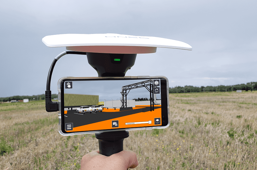
Look at your phone with the camera turned on. What you see is a real-time visual slice of the reality in front of you. Now, picture a 3D model of a proposed pipeline and easement lines, precisely tied to your location and superimposed over the live view. As you walk around the site, the model updates in real time to show the features from any vantage point. This is what AR for AEC and oil and gas is all about.
Such solutions are not altogether new or unique. We’ve all seen engineering designs projected over photos in software including fly-though visualizations on the desktop and on the web. What has changed is the ability to use AR in the field. There are numerous AR apps that run on a standard smartphone. With the addition of precise GPS for positioning and orientation, you can hold the full AR system in one hand. The system’s size and capabilities make it a ready tool for the demanding requirements of oil and gas development and operations.
Construction Management Made Easy
In many projects, stakeholders visit a site to assess proposed construction, which is commonly marked by stakes. But for many people, a few stakes and a 2D plan aren’t sufficient to provide an accurate perception of the project; AR changes that.
ONEC, a North American provider of engineering, procurement and construction (EPC) services for clients in the oil and gas, utilities and industrial sectors deploys AR for design planning, design reviews and construction management for its projects. “AR engages field and design staff at a level they haven’t been accustomed to,” says ONEC technologies director Joe Riordan. “Previously, operators and maintenance staff were handed something to operate and maintain but without much opportunity to provide input. Now they feel a part of it – they are making valuable inputs to the design that previously would have resulted in an expensive change order.”
Using AR, ONEC’s construction staff can now better visualize the end result. They can ask detailed questions and avoid requests for information (RFIs) that can bring a project to a halt. For example, operators can identify access or interference issues, or maintenance staff can identify inappropriate clearances for their tools or lifts. The approach fosters good cooperation among engineers, designers and construction people. “They’re having conversations they’ve never had before, resulting in a sense of pride in the end results,” Riordan says.
Companies such as ONEC have implemented AR to deliver realistic and accurate design reviews. The key benefit is being able to share real-time views from the field. Teams can evaluate multiple design alternatives without having to return to the site.
ONEC teams take designs to the field via Trimble SiteVision, a handheld AR solution (see sidebar). With its companion application, Team Viewer, the AR technology enables remote team members to see the project simultaneously. By using real-time, on-site AR, ONEC can involve more stakeholders in the effort to search for problem areas and identify opportunities for improvement.
AR provides a simple solution for relaying project status and site conditions to the project management team, safety coordinators or anyone on the team – even those offsite. Anyone on the site can use SiteVision to provide scheduled or ad hoc live views compared to the design models at any time.
When everyone has the same clear vision, it eliminates questions, disputes, and wasted time and resources. It results in significantly lower costs and schedule savings. Riordan says that once his clients see AR in action, they quickly embrace the new approach. “One project manager told us that he is a skeptic and was not crazy about some of these new technologies. He became a zealot within an hour because we saved him a lot of rework and mistakes were caught early on.”
Right to Move Forward
In Oklahoma, the engineering and surveying consulting firm Smith Roberts Baldischwiler (SRB) uses AR in working with landowners affected by energy development. To acquire the necessary rights and permits, SRB’s inhouse staff of landmen work with landowners to negotiate the location and terms of an easement or right-of-way. Reaching agreement often requires visits to the sites of proposed activities.
The landmen and landowners need accurate information that can be easily understood by technicians and laypeople alike. SRB Director of Surveying and Mapping, Taylor Denniston, says that situations often come up when a landman visits the landowner and has a paper copy of an easement or right-of-way location. But only having paper makes it hard for owners to conceptualize how it is really going to impact their land. In those cases, landowners will often ask for a few stakes to be set in the ground to help them better visualize the plan. It can take time to mobilize a survey crew, and per-day costs can add up quickly. Instead of 2D paper drawings, SRB uses augmented reality to provide accurate on-site visualizations of proposed easements or structures.
Using AR, the SRB agent can walk the site with the owner, who can see the right-of-way lines on the SiteVision display projected onto the ground and understand how it’s going to impact their property. If the owner requests changes, they can be noted, and the alignments revised for the final agreements. For example, some planned construction might take out trees that the owner wants to protect. Together, the owner and landman can agree on how to adjust the alignment to avoid the trees or other assets.
Like ONEC, SRB recognizes the value of AR as a planning tool for pipelines and other oilfield work such as pump stations and wellheads. SRB engineers can take the digital 3D models to the field for design checks and verification. Designers can drop the model onto the site and see what it will look like, how tall a structure will be and how it looks from nearby roads, as well as other impacts. The visualization helps SRB teams identify and resolve potential problems early in a project, thereby avoiding costly changes and delays that might occur after construction begins. “The ability to visualize the alignments, existing utilities and rights-of-way on the ground is almost priceless,” says Denniston. “It streamlines the process, and you can speed through a project very fast.”
A Stake in the Outcome
It’s clear that AR doesn’t replace the high-precision stakeout that surveyors provide for boundaries, excavation and construction. But on most projects, there is additional staking that often only serves to show rough limits or extents for clearing or fencing. Or stakes may be called for to answer a single question from a landowner, client or stakeholder.
Denniston notes that it’s not unusual to place stakes every 50 feet across a property, which can be an inconvenience. “The owner can’t mow, and they don’t know whether they can take out the stakes or not. AR is a non-[disruptive] way of showing somebody where the right-of-way line is.” The AR approach provides a quick, low-cost solution by replacing physical staking with accurate real-time visualization or “virtual stakes,” which do not affect the land at all.
Reducing Boundaries
As AR becomes increasingly ubiquitous in AEC and oil and gas, users are expanding the variety of uses. Early adopters such as ONEC and SRB have found AR useful for increasing stakeholder engagement, improving inspections and providing real-time project status. AR can show safe dig zones, delineate boundaries or reveal underground utilities.
Using AR to help identify clashes and issues before construction results in lower costs with fewer change orders. Users report increased confidence in the final project outcomes and, as a result, contractors can use hard-dollar (lump sum) bids versus time and materials.
Today’s AR solutions have demolished the barriers of cost and complexity commonly associated with new technologies. Augmented reality is part of the currency of our modern lives – both in professional and consumer applications. For oil and gas companies, a longtime dream has become a happy reality.
Headline photo courtesy of ONEC.
Stefania C. Radopoulou, PhD, works in outdoor augmented reality at Trimble.
Oil and gas operations are commonly found in remote locations far from company headquarters. Now, it's possible to monitor pump operations, collate and analyze seismic data, and track employees around the world from almost anywhere. Whether employees are in the office or in the field, the internet and related applications enable a greater multidirectional flow of information – and control – than ever before.